
ACR ResQLink View RLS PLB
4.8Editor score
Return Link Service confirmation
Five-year battery lifespan
No subscription required
Built-in buoyancy protection
Best locator beacon for hiking the PCT compares satellite messengers and personal locator beacons for navigation, SOS, tracking, durability, and trail
A locator beacon for hiking the PCT should provide dependable location information and emergency communication when cellular service disappears. The most useful models combine satellite SOS, navigation, tracking, rugged construction, and enough power for a demanding multi-day journey. Important differences include registration, coverage, messaging capability, battery life, and ease of use.
The products in this guide include dedicated personal locator beacons and subscription-based satellite communicators. They were compared using the supplied specifications, emphasizing the functions most relevant to PCT hikers: global rescue signaling, two-way messaging, location sharing, navigation support, physical durability, and extended battery life.
Each review explains how the device fits into a trail safety kit, identifies its strongest qualities, and notes practical limitations. The recommendations range from simple emergency beacons to advanced communicators for hikers who want regular check-ins. Product availability, service plans, and registration requirements can change, so buyers should verify current details before purchasing.
4.8Editor score

4.6Editor score

4.4Editor score
This side-by-side comparison covers ten emergency beacons and satellite communicators, highlighting the differences in rescue signaling, navigation, messaging, durability, and battery life that matter most to PCT hikers.




The ACR ResQLink View RLS PLB is a premium personal locator beacon with a 4.8 rating, the highest among the ten products considered. Its standout feature is Return Link Service, which confirms that Search and Rescue has received the distress signal. For a PCT hiker, that feedback can provide valuable reassurance that an emergency message entered the satellite system.
We may earn a commission when you buy through this link, at no additional cost to you.
The beacon supports GPS, Galileo GNSS, and MEOSAR compatibility for global positioning and rescue coverage. Its five-year battery life and more than 28 hours of operational life make it well suited to long-distance trail travel. A digital display, infrared strobe, built-in buoyancy, compact construction, and a multifunction clip system round out a design clearly oriented toward outdoor emergencies.
This is fundamentally a distress beacon rather than a general satellite communicator. It does not offer the routine two-way messaging, live tracking, weather forecasts, or group coordination found in the Garmin and Bivy products. Its advantages are simplicity, broad global compatibility, and the absence of a subscription requirement for basic rescue operation.
PCT hikers who want a dedicated, always-ready emergency beacon and can manage its primary purpose should consider this model. It is especially attractive for users who prioritize confirmation that a distress alert was received over the broader communication features of a subscription-based communicator.
Return Link Service tells the user that a rescue center has received the emergency signal, rather than merely showing that the beacon transmitted. This makes the RLS model especially useful for solo hikers concerned about whether a distress call was successfully relayed.
The stated five-year battery life allows a hiker to keep the beacon in a pack for an extended period without maintaining a frequent charging routine. More than 28 hours of operational life also provides a substantial emergency window.
We may earn a commission when you buy through this link, at no additional cost to you.
The ACR ResQLink View PLB425 is a compact, buoyant personal locator beacon rated 4.6 by customers. It is built around a clear purpose: sending an SOS distress signal with a GPS position directly to Search and Rescue forces worldwide. The 406 MHz emergency signal works with the 121.5 MHz homing signal without requiring a subscription.
We may earn a commission when you buy through this link, at no additional cost to you.
Its global coverage uses the three COSPAS-SARSAT satellite constellations, allowing the distress message to reach rescue agencies without a private monitoring center. Multiple visual signals, including a bright LED strobe and an infrared strobe, can assist rescuers during nighttime or poor-visibility searches. Attachment clips, straps, and lanyards make it practical to wear rather than simply store.
The PLB425 is less flexible than a satellite communicator because its core function is emergency alerting. Optional 406Link functionality supports self-tests, GPS tests, text messages, and email to multiple contacts, but routine messaging is not the central purpose of the device. Hikers should also distinguish emergency activation from non-emergency test procedures.
It is a strong choice for backpackers who want a dedicated rescue beacon without a recurring service plan. Those who need daily check-ins, group tracking, or a full communication channel should consider a satellite communicator instead.
The PLB425 sends its 406 MHz distress signal through the international COSPAS-SARSAT system, supporting emergency response well beyond cellular coverage. Its compatibility with 121.5 MHz homing equipment adds another way for rescuers to detect the beacon.
Buoyancy protects the beacon if it enters water, while the included clips, straps, and lanyards allow attachment to a pack, belt, or clothing. This wearable flexibility helps ensure the device remains accessible during an emergency.
We may earn a commission when you buy through this link, at no additional cost to you.
The Garmin inReach Mini 2 Flame Red Bundle is the editor's choice for hikers who want emergency response, regular communication, tracking, and navigation in one device. Its 4.6 rating reflects a strong customer reception, while the bundle includes a cable, charging adapters, a vehicle adapter, a microfiber cloth, and a portable power bank.
We may earn a commission when you buy through this link, at no additional cost to you.
Interactive SOS alerts can reach the Garmin Response coordination center for support and rescue coordination. Two-way satellite messaging works over the global Iridium network, and the device can also post to social media or communicate directly with another inReach unit. TracBack routing helps a hiker return along a traveled route, while MapShare and coordinate-bearing messages support location sharing.
The unit measures approximately four by two inches, weighs 3.5 ounces, meets MIL-STD-810 standards, and is rated IPX7 for water resistance. Its stated tracking life reaches 14 days in the default ten-minute interval and up to 30 days at a 30-minute interval. A digital compass and detailed weather updates add further utility on exposed PCT terrain.
This bundle is the most complete option for a hiker building a new safety kit. The extra charging accessories are useful for long trips, and the communicator's broad feature set is well matched to multiweek trail travel. Users who only need a dormant emergency beacon may prefer a simpler dedicated PLB.
Two-way messaging lets a hiker contact family, coordinate logistics, and request information while out of cellular range. This makes the Mini 2 more useful during ordinary trail delays as well as serious emergencies.
Longer tracking intervals can extend battery life substantially for multiweek trips. The included portable charger and multiple adapters add flexibility for charging from wall outlets, vehicles, and other compatible power sources.
We may earn a commission when you buy through this link, at no additional cost to you.
The orange Garmin inReach Mini 2 is a compact satellite communicator with a 4.6 rating. It gives PCT hikers two-way messaging, interactive SOS, location sharing, and route navigation in a package designed to fit easily into a pack or clothing pocket. The bright color also makes it easier to locate quickly in a shelter or emergency kit.
We may earn a commission when you buy through this link, at no additional cost to you.
TracBack routing can guide a hiker back toward the start of a recorded route, while the digital compass supplies heading information even while stationary. The Garmin Explore integration supports planning, topographical mapping, waypoints, courses, and activities. Pairing with compatible Garmin handhelds and wearables expands the available controls for messages and SOS functions.
Its most important limitation is the need for an active satellite subscription for the core communication and rescue services. The stated battery life reaches up to 14 days in ten-minute tracking mode, which is suitable for many trips but requires planning for longer journeys. Regulations concerning satellite communication devices can also vary by jurisdiction.
This is a strong general-purpose choice for hikers who already use Garmin tools or want a device that handles both navigation and communication. It may be the better daily trail tool than a dedicated beacon, while the separate bundle offers a more comprehensive accessory set.
TracBack, the digital compass, and Garmin Explore mapping make the Mini 2 more than an emergency messenger. It can support route decisions and everyday orientation in areas without a cellular data connection.
MapShare and coordinate-bearing messages give friends and family a clear view of the hiker's progress. Compatibility with Garmin wearables and handhelds can make remote communication more natural for users already invested in the ecosystem.
We may earn a commission when you buy through this link, at no additional cost to you.
The ZOLEO Satellite Communicator is a budget-friendly option for PCT hikers who want global messaging without carrying a full-featured handheld GPS. It earns a 4.4 rating and uses a compatible smartphone to transmit texts and emails over the Iridium satellite network, cellular service, or Wi-Fi, choosing the lowest-cost available network.
We may earn a commission when you buy through this link, at no additional cost to you.
Emergency SOS sends a GPS location to a 24-hour monitoring center, while Medical Assist provides a separate channel for non-emergency help. The device also supports unlimited check-ins, GPS coordinates, waypoint sharing, weather forecasts, and messages up to 900 characters. A dedicated phone number and email make it easier for contacts to reach the hiker when ordinary service is unavailable.
Its IP68 rating and stated battery life of more than 200 hours provide durable, long-lasting operation. The trade-off is dependence on a compatible smartphone and app-based workflow, which may feel less tactile during an emergency. A service plan is also required for the principal communications functions.
ZOLEO is well suited to hikers who already carry a smartphone, want lightweight packing, and need both routine communication and emergency assistance. It is less appealing to those who prefer a self-contained beacon with physical controls and no recurring connectivity requirement.
ZOLEO removes the need to learn a complex standalone messaging keypad. Hikers can use their phone for communication while the dedicated device handles the satellite connection.
A stated battery life exceeding 200 hours provides considerable operating margin for multiweek trail journeys. That endurance also reduces the urgency of carrying a dedicated battery for this device alone.
We may earn a commission when you buy through this link, at no additional cost to you.
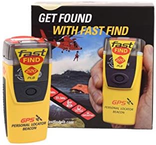
The McMurdo FastFind 220 is a dedicated personal locator beacon with a 4.5 rating. This US-programmed version is intended for registration with the United States country code, although the beacon can function internationally. Its first point of contact during an emergency would be the US Search and Rescue authorities with which it is registered.
We may earn a commission when you buy through this link, at no additional cost to you.
Activation is refreshingly direct: deploy the antenna, pull the anti-tamper seal, and press the ON button. That clear sequence reduces uncertainty when a hiker is injured, exhausted, or wearing gloves. Personal locator beacons of this type have been used in remote and challenging environments, and the FastFind 220 emphasizes simple operation in critical situations.
Registration is essential, and the supplied information emphasizes that it helps rescuers identify the owner and contact people who know the travel plan. Users outside the United States should not choose this programmed listing without confirming the correct country code. False activations can endanger lives and disrupt rescue resources, making responsible testing and storage essential.
The FastFind 220 is a practical pick for US-based PCT hikers who want a basic emergency beacon without the complexity of a satellite communicator. Its key advantage is focused simplicity, though it does not solve the need for everyday messages or live tracking.
The three-step activation process is easy to remember under stress. A simple beacon can be more useful to a hiker than a sophisticated device with controls they rarely use.
A completed registration connects the beacon to the relevant rescue authority and provides identity and contact details. Hikers should confirm that their personal information and travel information remain accurate.
We may earn a commission when you buy through this link, at no additional cost to you.
The Ocean Signal rescueME PLB1 is a highly compact emergency beacon with a 4.6 rating. At just four ounces, it is designed to add little weight to a PCT pack, and its one-handed operation makes activation possible even when an injury limits fine motor control.
We may earn a commission when you buy through this link, at no additional cost to you.
The PLB1 is 30 percent smaller than the maker's next-smallest beacon and attaches readily to a backpack or life jacket using the included mounting clip. A 66-channel GPS receiver supports positioning, while a one-candela high-intensity strobe improves visibility during rescue operations.
Waterproofing to 49 feet adds confidence around lakes, streams, and wet weather. The stated seven-year battery life and more than 24 hours of operational life make it suitable for long-term readiness. The main limitation is its narrow feature set: it is designed to alert rescue services rather than support two-way communication, live tracking, or route guidance.
PCT hikers who prioritize minimum weight and uncomplicated emergency activation should give this beacon serious consideration. It is less appropriate for a traveler who wants one device to handle communication, navigation, and daily check-ins.
The four-ounce housing and compact dimensions are especially appealing on long routes where every item affects comfort. A dedicated clip makes it easy to keep the beacon accessible rather than buried in deep gear storage.
Waterproofing to 49 feet and a high-intensity strobe improve readiness in exposed environments. These features are valuable where rain, creek crossings, and poor visibility are realistic concerns.
We may earn a commission when you buy through this link, at no additional cost to you.
The renewed Garmin inReach Mini is a compact standalone satellite communicator with a 4.2 rating. It provides two-way text messaging over the global Iridium network and can trigger an interactive SOS to a 24-hour search and rescue monitoring center, making it a credible option for PCT safety and routine communication.
We may earn a commission when you buy through this link, at no additional cost to you.
Free use of the Garmin Earthmate app with compatible devices provides downloadable maps, NOAA charts, and color aerial imagery. Optional weather forecast packages deliver detailed updates to the device or a paired device. Messages can also be sent through compatible Garmin handhelds and connected wearables, which is useful for hikers with an established Garmin setup.
As a renewed product, its physical condition may not match a new unit, and it represents an older generation compared with the Mini 2. Buyers should inspect the listing details, confirm expected condition, and verify that the included functions meet their needs. A satellite subscription remains necessary for core communication and rescue services.
The renewed Mini appeals to budget-conscious hikers who value Garmin compatibility and offline mapping. It is a sensible secondary device or value-oriented purchase, provided the condition is acceptable and the unit is fully functional.
Downloadable maps, NOAA charts, and aerial imagery make the renewed Mini more versatile than a basic text-only terminal. Offline access is especially helpful where route research and navigation are priorities.
A renewed device may show signs of previous use and will not include the newest capabilities of the Mini 2. Hikers should review the condition description, test the unit, and keep a charging plan in reserve.
We may earn a commission when you buy through this link, at no additional cost to you.
The ACR Bivy Stick is an Iridium satellite communicator with a 3.8 rating. It combines two-way SMS, email, GPS tracking, offline maps, SOS, weather updates, and location sharing through the Bivy app for compatible iOS and Android devices. The feature set is particularly relevant to PCT hiking groups that want to monitor one another's progress.
We may earn a commission when you buy through this link, at no additional cost to you.
GroupTrack allows messaging and sharing locations with up to 12 people, while live tracking can display exact coordinates and a breadcrumb trail. Each activated device receives a dedicated phone number and email address. GPS information can also track pace, mileage, and altitude, and the app provides access to more than 50,000 curated outdoor adventures.
The Bivy Stick depends on service plans, which continue after an initial device commitment. Its lower customer rating may reflect variation in user experience, so prospective buyers should assess app compatibility and service reliability before committing. It also overlaps with other communicators that provide more specialized trail navigation hardware.
For a family, guide team, or group crossing the PCT, the Bivy Stick offers one of the strongest collaboration tools in this list. Solo hikers who only need emergency rescue may find a dedicated PLB simpler, while navigation-focused users may prefer a dedicated handheld.
GroupTrack's support for up to 12 people is a meaningful advantage for families or teams traveling together. Sharing live locations and a breadcrumb trail can help groups monitor progress across long gaps.
Downloadable global maps and a large library of curated adventures support route planning away from service. Built-in GPS can track pace, mileage, and altitude even when cellular communication is unavailable.
We may earn a commission when you buy through this link, at no additional cost to you.
The Motorola Defy Satellite Link is an entry-level satellite messenger with a 3.7 rating. It provides two-way satellite-enabled messaging for compatible iOS and Android smartphones, allowing PCT hikers to send text messages and check-ins even when cellular coverage is unavailable.
We may earn a commission when you buy through this link, at no additional cost to you.
Its dedicated check-in control can send coordinates or a message to selected contacts, while SOS assistance can be triggered without a cellular connection. The supplied information states that unlimited SOS is included with service plans. The device is intended as a compact companion for a phone rather than a full standalone GPS unit.
The lowest rating in the group suggests that prospective buyers should investigate compatibility and expected user experience carefully. Service plans are required, and the device lacks the offline mapping, live tracking, route guidance, weather details, and group features offered by the more specialized communicators. It should not be confused with a fully independent navigation device.
Motorola may suit a hiker who wants a relatively simple way to stay in touch without carrying a larger handheld. It is best viewed as an economical satellite communication tool, while users with demanding PCT navigation needs should choose a more capable GPS or communicator.
The Defy Satellite Link lets a hiker send coordinates and messages through a compatible smartphone. This approach can minimize learning demands, although it also creates a dependency on the phone workflow.
SOS assistance is designed to operate without a cellular connection, which is the essential requirement in remote trail locations. Users should test the workflow before departure and understand the service features included with their plan.
We may earn a commission when you buy through this link, at no additional cost to you.
The right safety device depends on trip length, navigation habits, group needs, and willingness to manage service plans. PCT hikers should compare emergency functions first, then assess communication, mapping, power, durability, and registration requirements.
A true personal locator beacon is built to send a distress alert through satellite rescue networks, while a satellite communicator adds messaging, tracking, and often navigation. Dedicated PLBs are simpler to carry and can operate without a subscription for core rescue functions, making them attractive to hikers who want a permanent emergency backup. Communicators offer more day-to-day usefulness but require active service and a charged device.
Look for global satellite compatibility and support for multiple positioning systems when hiking beyond reliable cellular coverage. Products using international rescue constellations or the Iridium network are designed for broad operation. GPS, Galileo GNSS, and MEOSAR support can improve positioning options, while offline maps are useful because an accurate emergency location does not eliminate the need to navigate safely.
Two-way messaging allows a hiker to contact family, coordinate a delayed departure, or request help before conditions become critical. Live tracking, MapShare, coordinate-bearing messages, and group tracking can show progress across the PCT. Dedicated beacons generally do not provide these routine communication functions, so hikers should decide whether a one-way distress signal is enough for their risk tolerance.
Battery endurance should match the planned trip and the amount of time the device will remain active. A PLB with a multi-year battery life is easy to keep ready, while communicators that send frequent tracking updates can consume power more quickly. Review stated battery duration under the tracking interval you expect to use and consider carrying a small power reserve for extended routes.
The PCT crosses desert heat, exposed ridgelines, forests, water, mud, and changing weather. Look for water resistance, rugged construction, secure attachment options, and a form factor that can be worn or mounted on a pack. Buoyancy is valuable around water, while high-intensity strobes help rescuers identify a beacon in poor visibility. Always confirm the stated environmental rating and avoid assuming a device is submersible unless the manufacturer says so.
PLBs generally require registration with the appropriate national rescue authority, and incorrect country programming can affect how an emergency is handled. Satellite communicators require an active service plan for messaging, tracking, and monitored SOS. Review the registration process before the trip, keep personal contact details current, and confirm whether the device uses a dedicated number, email address, app, or pairing workflow.
A device carried on every PCT day should be small, secure, and easy to operate under stress. Ultra-light PLBs can be clipped to a pack, while communicators may integrate more comfortably with a smartphone or handheld GPS. Consider battery bulk, mounting options, glove-friendly controls, and whether the device can remain accessible without taking off the entire pack.
A communicator can serve as more than an emergency tool if it includes mapping, waypoints, route guidance, and group features. The Garmin models integrate with Garmin handhelds, wearables, and the Explore platform, while the Bivy Stick emphasizes group tracking. Dedicated PLBs excel at signaling but do not replace a map, compass, or route knowledge. A locator beacon should complement navigation equipment rather than become the hiker's only source of direction.
Before leaving home, register the PLB or activate the satellite communicator, complete any required identity checks, and confirm that the relevant rescue service or monitoring center is operational. Update emergency contacts and enter a realistic travel plan. A dedicated PLB should be tested according to the manufacturer's guidance without creating a false distress alert, while a communicator should be used to send a test message and verify that both outbound and inbound communication work.
Carry the device where it remains accessible and protected from impact, moisture, and excessive heat. A belt, pack strap, life jacket, or chest attachment can reduce the chance of leaving it behind at a camp. Recheck the attachment during long breaks, and keep the unit dry even when its water-resistance rating suggests it can handle rain or splashing. For a smartphone-based system, protect the phone and make sure its operating system and communications app are current.
On the trail, use the device according to its intended role. Follow a planned tracking interval rather than leaving continuous updates on unnecessarily, and learn how to conserve power before a long section without resupply. Test the physical controls, verify that GPS coordinates appear correctly, and make sure your contacts understand how to interpret a location update. If the device is ever activated accidentally, contact the responsible monitoring or rescue organization immediately and do not ignore the alert.
A locator beacon is not a substitute for navigation skills, a paper map, a compass, or sound trip planning. It is nevertheless a valuable layer of protection for remote sections where cellular service is unreliable and an injury could make self-rescue difficult. A dedicated PLB offers focused emergency signaling, while a satellite communicator can also support check-ins, messaging, tracking, and navigation.
Choose a PLB if you want a simple, dedicated emergency device that can remain ready for years and does not require a subscription for its core rescue function. Choose a satellite communicator if regular check-ins, two-way messages, live tracking, weather information, and group coordination are important. Some hikers carry both, using a communicator for communication and a PLB as a backup.
Yes. Their core emergency function uses satellite networks rather than cellular towers, making them suitable for remote PCT locations without wireless coverage. Dedicated PLBs send distress signals through government-supported satellite systems, while satellite communicators use services such as Iridium. The exact capabilities depend on the product, and communicators still require an active service plan.
Register the beacon with the appropriate national rescue authority using accurate owner and emergency contact information. Country programming matters because it determines which authority initially receives the emergency. US-programmed models are intended for US registration, and international users may need a version configured for their country. Keep the registration information and travel plan current throughout the hiking season.
The right interval depends on the device's battery life, your party, and the length of the planned segment. More frequent updates provide better visibility but consume more power. Hikers on a multiweek trip should select an interval that preserves sufficient capacity for emergencies, then use a portable battery or other charging method if the route extends beyond the stated endurance.
A dedicated PLB is primarily an emergency signaling device. It may provide GPS positioning and visual strobes, but it should not replace a map, compass, or capable GPS unit. Satellite communicators with offline maps, waypoints, TracBack routing, and heading information offer more navigation support, but hikers should still carry redundant navigation tools and know how to use them.
Contact the monitoring center or emergency authority as quickly as possible and clearly state that the alert was accidental. Do not wait for rescuers to arrive before attempting to cancel the incident. False alerts can divert valuable resources, and deliberately activating an emergency beacon can carry serious legal consequences. Practice the normal test procedure and only use the distress control in a genuine emergency.
A dedicated number can make contact easier because friends and family do not need to know the device's satellite number or coordinate format. Some models also assign an email address, while others provide app-based access and coordinates in messages. Hikers should send these details to their emergency contacts before departure and confirm that messages can be received as well as sent.
The ACR ResQLink View RLS PLB stands out as the premium dedicated beacon because Return Link Service confirms receipt of a distress signal. The Garmin inReach Mini 2 Flame Red Bundle is the most versatile complete package, combining interactive SOS, two-way messaging, live navigation, and charging accessories. The ZOLEO Satellite Communicator provides the strongest budget-oriented balance of phone-based messaging, monitoring, durability, and battery endurance.
Prioritize the failure mode you want to prevent. Choose a rugged PLB when your main requirement is a simple distress signal with long readiness, or choose a communicator when check-ins, weather information, mapping, and family contact are equally important. Whichever category you select, verify registration, test the controls, carry a redundant navigation solution, and make sure the device will remain accessible throughout every PCT segment.
Finally, check the current listing and service details before purchasing. Device revisions, activation terms, coverage, accessory bundles, and regulatory requirements can change, so confirm that the exact model meets your PCT itinerary and that the associated service is active before departure.